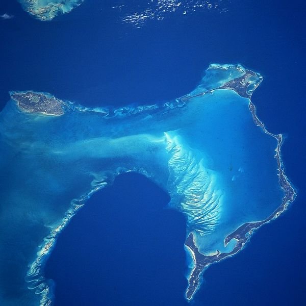
 Eleuthera Island, Bahamas
Source: https://en.wikipedia.org/wiki/File:New_providence_eleuthera.jpg
Author: NASA

Eleuthera is a long, narrow island in the Bahamas. Located some 80 km (50 mi) to the east of New Providence, it measures 180 km (110 mi) end to end, but is less than a mile across at some points. The northernmost part of the island is at Spanish Wells while the southernmost part is at Cotton Bay Beach.
Eleuthera covers 518 sq km (200 sq mi) and has a population of 12,000 people (2012 estimate). The highest point on the island is 60 m (200 ft) above sea level. The natives of the island were the Taino or Arawak indigenous people. In the 16th century, they were captured by the Spanish and enslaved to work at the mines on the island of Hispaniola, leading to their annihilation for Eleuthera.
In the 17th century, puritan pilgrims arrived from Bermuda to settle at Eleuthera. They named it after the Greek word Ἐλευθερά meaning "liberated". There are a number of towns and villages on the island, among them Alice Town, Gregory Town, Governor's Harbour and Tarpum Bay.
Due to its long history, Eleuthera has a number of historic sights. Most of today's visitors come for its natural attractions, such as Hatchet Bay Caves, Lighthouse Beach and Ocean Hole. Off the northeast coast of Eleuthera Island is Harbour Island. Off the west coast, near the northernmost tip of Eleuthera Island is the island of Spanish Wells.
Egg Island
To the west of Eleuthera Island, and southwest of Spanish Wells is Egg Island. It got this name because the people of nearby islands rear chickens here. They then leave the chicken to lay eggs on their own, and come back from time to time to collect the eggs. The island itself is in the shape of a crescent. It has good beaches that are protected by a coral reef.
 Latest updates on Penang Travel Tips
About this website

Dear visitor, thank you so much for reading this page. My name is Timothy Tye and my hobby is to find out about places, write about them and share the information with you on this website. I have been writing this site since 5 January 2003. Originally (from 2003 until 2009, the site was called AsiaExplorers. I changed the name to Penang Travel Tips in 2009, even though I describe more than just Penang but everywhere I go (I often need to tell people that "Penang Travel Tips" is not just information about Penang, but information written in Penang), especially places in Malaysia and Singapore, and in all the years since 2003, I have described over 20,000 places.
While I try my best to provide you information as accurate as I can get it to be, I do apologize for any errors and for outdated information which I am unaware. Nevertheless, I hope that what I have described here will be useful to you.
To get to know me better, do follow me on Facebook!
Copyright © 2003-2025 Timothy Tye. All Rights Reserved.

 Go Back