 Moon over Death Valley National Park at sunrise, California/Nevada
 http://commons.wikimedia.org/wiki/File:Death_Valley_sunrise_California.jpg
 romainguy
Death Valley National Park is a national park covering 5,262 sq mi (13,630 sq km) in eastern California and a small section of 8 sq mi (19 sq km) in southern Nevada. The park encompasses several mountain ranges, the Saline Valley, parts of Panamint Valley and almost all of Death Valley. It was declared a National Monument in 1933, and redesignated a national park on 31 October, 1994.
Death Valley National Park is the hottest and driest national park in the United States. The Badwater Basin, within the park, is also the second-lowest point in the Western Hemisphere, at 282 feet (86 m) below sea level. Just 85 miles (137 km) to the west is Mount Whitney, rising to 14,505 ft (4,421 m)
 Twenty Mule Team Canyon, Death Valley National Park
 http://commons.wikimedia.org/wiki/File:Death_Valley,19820817,Twenty_Mule_Team_Canyon.jpg
 Roger469
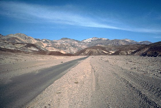
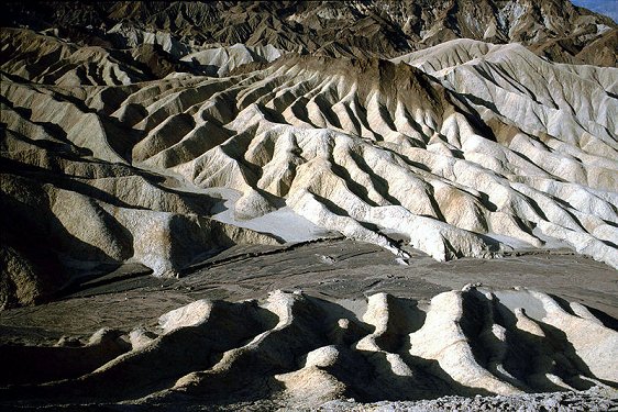
The landscape of Death Valley National Park is one of hot sand dunes with views of snow-capped mountains in the distance. In between you will come across multicolored rocks, canyons and a wilderness which remarkably still sustain life.
The wildlife in Death Valley has adapted to the harsh environment over time. Among its resident creatures include Bighorn sheep, coyote and the Death Valley Pupfish. Humans also lived here, a thousand years ago, as evident by the petroglyphs left behind by the Timbisha Shoshone people who led a nomadic lifestyle of hunting game and gathering beans.
 Zabriskie Point, Death Valley National Park
 http://commons.wikimedia.org/wiki/File:Death_Valley,19820817,Zabriskie_Point,Badlands_at_rise.jpg
 Roger469
Visiting Death Valley National Park, California/Nevada
California State Highway 190 cuts through Death Valley National Park from east to west. On the east, US Highway 95 skirts the park from north to south.Please note: GPS Navigation in Death Valley is notoriously unreliable. Many people using GPS are taken to dead ends and closed roads. I recommend that you arm yourself with the most up-to-date map before venture into this deadly valley. Be sure also to have a full tank of gas. You never know where the next station will be.
The Furnace Creek Visitor Center & Museum is located beside CA-190 in the Death Valley. The center is open daily from 8:00 am to 5:00 pm Pacific Time. Phone (760) 786-3200. It will be closed for renovation from 15 Nov, 2010, and during that time a temporary center is opened at nearby Furnace Creek Ranch.
There is an entrance fee of $20 per car, inclusive driver and passengers, valid for 7 days. Individuals arrival on other forms of transport are charged $10 per person, valid for 7 days.
 Badwater Basin, the lowest spot in the United States
 http://commons.wikimedia.org/wiki/File:Badwater_panorama.jpg
 Ivan, Hike395
List of National Parks in the United States
 Latest updates on Penang Travel Tips
About this website

Dear visitor, thank you so much for reading this page. My name is Timothy Tye and my hobby is to find out about places, write about them and share the information with you on this website. I have been writing this site since 5 January 2003. Originally (from 2003 until 2009, the site was called AsiaExplorers. I changed the name to Penang Travel Tips in 2009, even though I describe more than just Penang but everywhere I go (I often need to tell people that "Penang Travel Tips" is not just information about Penang, but information written in Penang), especially places in Malaysia and Singapore, and in all the years since 2003, I have described over 20,000 places.
While I try my best to provide you information as accurate as I can get it to be, I do apologize for any errors and for outdated information which I am unaware. Nevertheless, I hope that what I have described here will be useful to you.
To get to know me better, do follow me on Facebook!
Copyright © 2003-2025 Timothy Tye. All Rights Reserved.

 Go Back