 Fargo, North Dakota
Source: https://commons.wikimedia.org/wiki/File:Fargo_North_Dakota.jpg
Author: Tim Kiser

Fargo is the biggest city in North Dakota. It covers 37.9 sq mi (98.3 sq km) and has a population of 106,000 (2011 estimate). The metropolitan area which includes Fargo, West Fargo ane the cities of Moorhead and Dilworth in Minnesota has a total population of 209,000. Fargo is in the Central Time Zone, which is six hours behind Coordinated Universal Time (UTC-6) and five hours during Daylight Saving Time.
The city of Fargo is at an average elevation of 904 ft (274 m). The Red River flows through it heading north to empty into Lake Winnipeg in Manitoba, Canada.
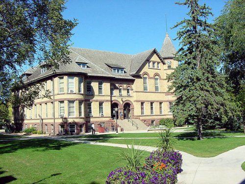
 Campus of North Dakota State University in Fargo
Source: https://commons.wikimedia.org/wiki/File:NDSU_Campus_1.jpg
Author: Unimatic1140

Fargo was founded in the 1870's and was initially called Centralia. When the Northern Pacific Railway extended its line to the city, it was renamed in honor of the director of the railway company, William Fargo, who is also the founder of the Wells Fargo, today one of the largest banks in the United States.
Fargo has survived a number of calamities. Early in its history, it was struck by fire which razed much of downtown. Then in 1957, it was hit by a violent tornado which tore through the northern part of the city.
The largest shopping mall in Fargo, also the largest in North Dakota, is West Acres Shopping Center, opened in 1972, with four anchor tenants. The mall is located near the intersection of Interstate 29 and 94, the two Interstate highways serving the city. While it brought growth to the area, the mall has also contributed to a decline in retail activities in downtown Fargo.
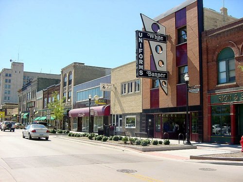
 Street in downtown Fargo
Source: https://commons.wikimedia.org/wiki/File:Fargo_Streets.jpg
Author: Unimatic1140

Visiting Fargo, North Dakota
Fargo's Hector International Airport (FAR) is just 3 miles from the central business district of Fargo. It receives flights from major cities including Chicago, Denver, Las Vegas, Los Angeles, Minneapolis/St Paul, Orlando, Phoenix and Salt Lake City.Interstate 29 and 94 are the two Interstate highways connecting Fargo with the rest of the country. The I-29 runs north-south connecting it with Grand Forks on the north, all the way to the Canadian border, and Sioux Falls to the south, while I-94 connect it with Bismarck to the west and Minneapolis to the southeast.
Places of Interest in Fargo, North Dakota
- Children's Museum
- Fargo Air Museum
- FargoDome
- Plains Art Museum
- Roger Maris Museum
 Latest updates on Penang Travel Tips
About this website

Dear visitor, thank you so much for reading this page. My name is Timothy Tye and my hobby is to find out about places, write about them and share the information with you on this website. I have been writing this site since 5 January 2003. Originally (from 2003 until 2009, the site was called AsiaExplorers. I changed the name to Penang Travel Tips in 2009, even though I describe more than just Penang but everywhere I go (I often need to tell people that "Penang Travel Tips" is not just information about Penang, but information written in Penang), especially places in Malaysia and Singapore, and in all the years since 2003, I have described over 20,000 places.
While I try my best to provide you information as accurate as I can get it to be, I do apologize for any errors and for outdated information which I am unaware. Nevertheless, I hope that what I have described here will be useful to you.
To get to know me better, do follow me on Facebook!
Copyright © 2003-2025 Timothy Tye. All Rights Reserved.

 Go Back