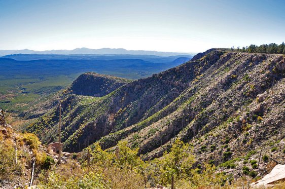
 Mogollon Rim, Arizona
Source: https://commons.wikimedia.org/wiki/File:Mogollon_Rim_near_FR321.jpg
Author: Coconino National Forest

Mogollon Rim is a series of cliffs and canyons across Arizona. This geological feature extends across the northern part of Yavapai County over a distance of 200 miles (320 km) eastwards towards the border with New Mexico.
The Mogollon Rim is a rugged escarpment on the southwestern limits of the Colorado Plateau. It was caused by erosion and faulting, which created limestone and sandstone cliffs and canyons. The feature was named after Don Juan Ignacio Flores Mogollón, the Spanish Governor of New Mexico between 1712-1715.
Viewing the Mogollon Rim, Arizona
The Mogollon Rim extends over a long distance. Among the cities and towns within its proximity include Payson, Sedona, Show Low and Alpine. Interstate 17 cuts through it. Latest updates on Penang Travel Tips
About this website

Dear visitor, thank you so much for reading this page. My name is Timothy Tye and my hobby is to find out about places, write about them and share the information with you on this website. I have been writing this site since 5 January 2003. Originally (from 2003 until 2009, the site was called AsiaExplorers. I changed the name to Penang Travel Tips in 2009, even though I describe more than just Penang but everywhere I go (I often need to tell people that "Penang Travel Tips" is not just information about Penang, but information written in Penang), especially places in Malaysia and Singapore, and in all the years since 2003, I have described over 20,000 places.
While I try my best to provide you information as accurate as I can get it to be, I do apologize for any errors and for outdated information which I am unaware. Nevertheless, I hope that what I have described here will be useful to you.
To get to know me better, do follow me on Facebook!
Copyright © 2003-2025 Timothy Tye. All Rights Reserved.

 Go Back