
 View from Bearpaw High Sierra Camp, across Kaweah Valley, at Sequoia National Park, California
 http://commons.wikimedia.org/wiki/File:Bearpaw_HiSierraCamp_view.jpg
 Dcrjsr
Sequoia National Park is a national park in Tulare County, California. Covering 404,051 acres (1,635 sq km) in the southern Sierra Nevada, it is an outstanding park with a great diversity of landscapes.
The Sequoia National Park has two major highlights: the General Sherman tree, the largest tree on earth, and Mount Whitney, at 14,505 ft (4,421 m), the tallest mountain in the contiguous 48 United States.
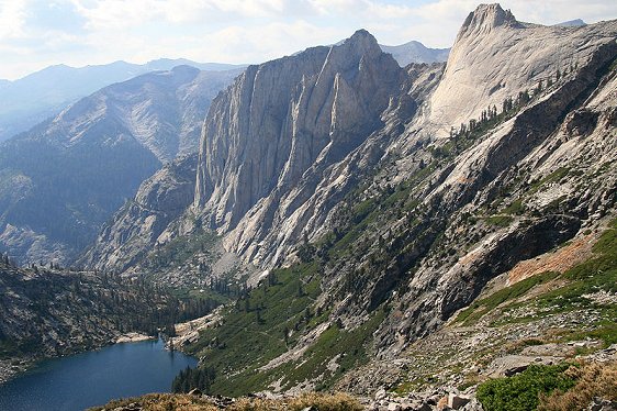 Hamilton Lake, Valhalla Cliffs, Sequoia National Park
 http://commons.wikimedia.org/wiki/File:Kaweah_downValley.jpg
 Dcrjsr
Sequoia National Park is located east of Visalia, California, and contiguous with Kings Canyon National Park immediately to the north. The national park has a Giant Sequoia (Sequoiadendron giganteum) forest that continues into the General Grant Grove of Sequoia trees in Kings Canyon National Park.
The area has always had human presence going back into prehistoric times. The earliest people to live here were the Monachee Native Americans who lived along the Kaweah River in the Foothills region. Before the first European arrived, smallpox had already reached the area, decimating the Native American population.
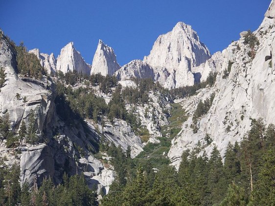 Mount Whitney, California
 http://commons.wikimedia.org/wiki/File:Mount_Whitney_September_2009.JPG
 Cullen328
The first European, by name, to build his home here was Hale Tharp, who had his home hacked out of a hollow in a Giant Sequoia trunk. A front running in environmental awareness, Tharp led a campaign against indiscriminate logging. The Giant Sequoia was saved from excessive logging when it was discovered that its wood splinters easily.
Tharp was often visited by famous naturalist John Muir, who was invited to stay in Tharp's log cabin. That log cabin, built in 1861, is still around today. It was added to the National Register of Historic Places on 8 March, 1977.
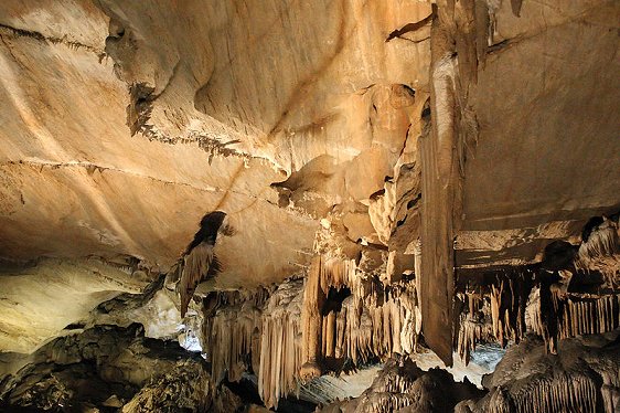 Crystal Cave, Sequoia National Park
 http://commons.wikimedia.org/wiki/File:Crystal_Cave.jpg
 David Liu
There are some 240 caves within the Sequoia National Park, including Lilburn Cave, which at 20 miles (32 km) in length, is the longest cave in California. Only one cave is open to casual visitors, Crystal Cave, which at 3.4 miles (5.5 km) is nonetheless the second longest cave in the park.
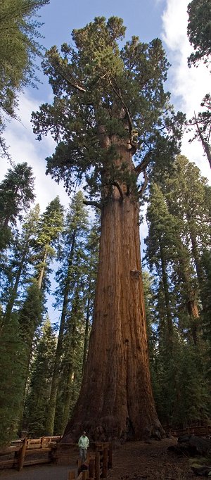 General Sherman tree, Sequoia National Park
 http://commons.wikimedia.org/wiki/File:General_Sherman_1469870071.jpg
 Kimon Berlin
Attractions of Sequoia National Park
Sequoia National Park has a number of attractions. In addition to those already mentioned, here are some more:- Sherman Tree Trail is a 0.8-mile trail to the base of the General Sherman tree.
- Tunnel Log is a tunnel cut through a falled Giant Sequoia tree. It measures 275 ft (84 m) in length and is 21 ft (6.4 m) in diameter. It fell in 1937 due to natural causes, and blocked the park road. Work crew cut the tunnel to make the road passable.
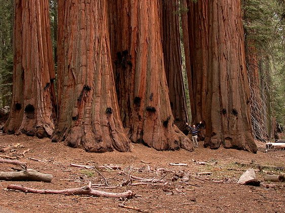
- Giant Forest is a forest famous for its grove of Giant Sequoia trees. Located at an elevation of 6,000 ft, it has five of the ten most volumnous trees on the planet, including the General Sherman tree.
- General Sherman tree is the biggest tree on earth. It stands at a height of 275 ft (83.8 m) and has a base diameter of 36.5 ft (11.1 m). It is the largest known non-clonal tree by volume, and is estimated to be between 2,300 and 2,700 years old.
- Crescent Meadow is a meadow rimmed by Sequoia trees. It is on the western end of the High Sierra Trail.
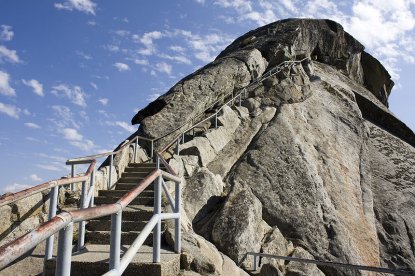
- Moro Rock is a huge granite rock at the center of the park. In the 1930's steps were cut into the rock for visitors to climb to the top, which affords a panoramic view of the park, at an elevation of 6,725 ft (2,050 m).
 Moro Rock
 http://commons.wikimedia.org/wiki/File:Moro_Rock_-steps-9Sept2008.jpg
 Birdyland
Visiting Sequoia National Park, California
The popular entrance into Sequoia National Park is by taking California State Highway 198 from the town of Three Rivers, at Ash Mountain, with an elevation of 1,700 ft (520 m). At this level, the landscape is one of blue oak woodlands, foothills chaparral, grassland and steep, mild river valley.As you climb higher, you will notice a gradual change in the vegetation. At between 5,500 and 9,000 ft (1,700 and 2,700 m), montane forest dominates the landscape, with coniferous trees such as the Ponderosa pine, Jeffrey pine, Sugar pine, Lodgepole pine, white fir and red fir.
 Giant Sequoias known as the House Group
 http://commons.wikimedia.org/wiki/File:TheHouseGroupGiantForest.JPG
 Paul Rudenko
An alternative, if you are coming from Fresno, is to take California State Highway 180 heading east and then Highway 198 to reach Sequoia National Park.
Both national parks are open all year round, although some parts of the parks may be snowed in from November through May. Highway 198 takes you from the Grant Grove area to Sequoia National Park.
Entrance fees of $20, valid over 7 days, allows you to enter Kings Canyon, Sequoia and the Hume Lake District of Sequoia National Forest/Giant Sequoia National Monument. Other permits are required for overnight backpacking, hiking in the Mt. Whitney area, fishing, visiting Crystal Cave (tickets available at Foothills and Lodgepole visitor centers), and commercial filming.
List of National Parks in the United States
 Latest updates on Penang Travel Tips
About this website

Dear visitor, thank you so much for reading this page. My name is Timothy Tye and my hobby is to find out about places, write about them and share the information with you on this website. I have been writing this site since 5 January 2003. Originally (from 2003 until 2009, the site was called AsiaExplorers. I changed the name to Penang Travel Tips in 2009, even though I describe more than just Penang but everywhere I go (I often need to tell people that "Penang Travel Tips" is not just information about Penang, but information written in Penang), especially places in Malaysia and Singapore, and in all the years since 2003, I have described over 20,000 places.
While I try my best to provide you information as accurate as I can get it to be, I do apologize for any errors and for outdated information which I am unaware. Nevertheless, I hope that what I have described here will be useful to you.
To get to know me better, do follow me on Facebook!
Copyright © 2003-2025 Timothy Tye. All Rights Reserved.

 Go Back