 Baphuon
Source: https://commons.wikimedia.org/wiki/File:Baphuon,_Angkor_Thom,_Camboya,_2013-08-16,_DD_09.jpg
Author: Diego Delso

Author: Diego Delso

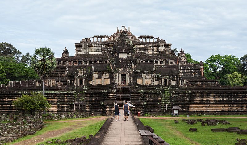
Baphuon ប្រាសាទបាពួន (GPS: 13.44361, 103.8562) is a massive temple-mountain in Angkor Thom, located to the northwest of the Bayon. It was built in the middle of the 11th Century by King Udayadityavarman II who reigned from AD 1050 to AD 1066. I always love to tell the story of the restoration of Baphuon. It is an example of how much restoration work can go to disarray. Even as I wrote this, restoration work is still progressing at an understandably snail's pace.
Approaching Baphuon.
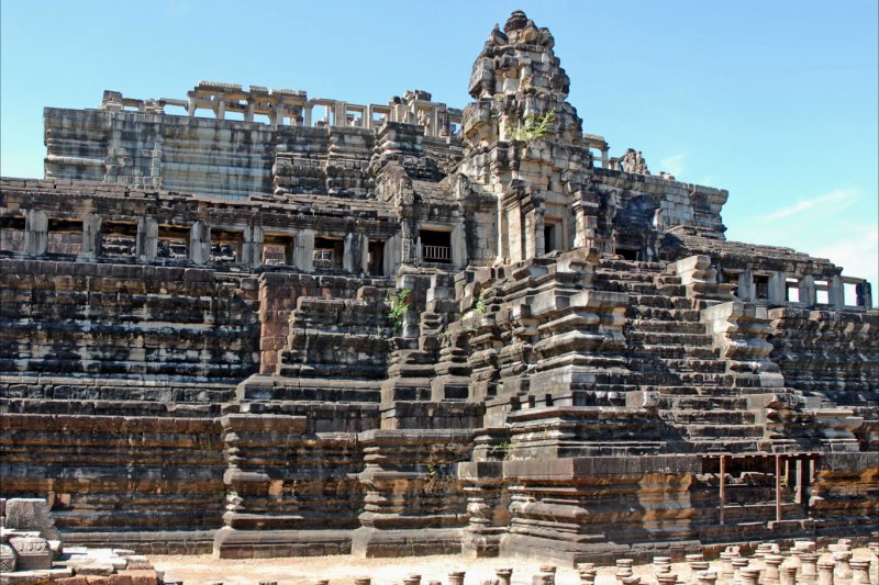
The step pyramid of Baphuon.
View of Baphuon from the front. Alas, climbing it is now forbidden.
Baphuon is  in the centre of the Map of Angkor
The Baphuon temple was built by King Udayadityavarman II in the 11th century. It is located within Angkor Thom, near the Royal Palace. In fact, when the Baphuon was built, there was no Angkor Thom yet. At the time of its completion in 1060, the Baphuon was the largest temple of its time, surpassed only when Angkor Wat was built a century later. The walls of Angkor Thom was also built much later, with the Bayon temple added in around then.
The Baphuon is the temple that restorers from EFEO (École Française d'Extrême Orient) dismantled and now, are having difficulties putting the pieces back together again. It was not completely their fault.
 Baphuon
Source: https://commons.wikimedia.org/wiki/File:Le_Baphuon_(Angkor)_(6832283873).jpg
Author: dalbera

Author: dalbera

The Baphuon was in a poor condition to begin with. Even in ancient times, some effort was made to restore it when part of the temple collapsed into itself due to its massive weight and to rain that filter through its stones.
The team from EFEO had intended to restore it the same as was done for another ancient monument, the Borobudur. This technique, called anastylosis, was carried out successfully on another Angkor temple, the Banteay Srei.
The Cambodian civil war broke out soon after the dismantling. As a result, the restorers were banished from the country and many of their local assistants were killed. When war ended and the EFEO restorers under the leadership of Pascal Royere were allowed back, they found that all the documents relating to the dismantling of the Baphuon had been destroyed. As a result of that, they had to piece together 300,000 pieces of this monumental jigsaw puzzle. At first, they tried to use a computer programme to make sense of this big jumble. That proved unproductive, so ultimately they relied on their own judgement.
The Baphuon is built as a temple mountain to symbolise Mount Meru. Its rectangular sandstone walls measure 425 m by 125 m (1394 ft by 410 ft). Like most Angkor temples, Baphuon's main entrance is on the east. There is a 200 m (656 ft) long causeway supported by three rows of short, round columns forming a bridge to the main temple. To get a superb view of the four-faced tower of Bayon framed against the doorway of the Baphuon, as you walk along the approach, turn left at the east gopura and walk to the end of the gallery.
A central prasat, or tower shrine, once crowned the top of the Baphuon, but it has collapsed long time ago. Baphuon is built on a rectangular sandstone base of five diminishing tiers, rather like a step pyramid. The first, second and third levels are surrounded by concentric sandstone galleries.
At the time of my first visit, in 2002, the Baphuon was still a big heap of dismantled stones. When I returned in February 2006, I see that a lot of progress has been made, but it will be quite some time before the Baphuon is ready to receive visitors again.
By May 2006 (after my visit), I learned that tourists were finally allowed back into the Baphuon site to watch the restoration in progress. It is estimated that restoration will take another two years from then to complete.
How to reach the Baphuon
Baphuon is located within Angkor Thom, about 400 meters northwest from the Bayon. Considering it is still under massive restoration, you might not be allowed to explore the site. However, you would still be able to walk around it or view it from the wall of the Royal Palace or from the Terrace of the Elephants. Until the Baphuon is fully restored, it is not yet a pretty sight. Latest updates on Penang Travel Tips
 Map of Roads in Penang
Looking for information on Penang? Use this Map of Roads in Penang to zoom in on information about Penang, brought to you road by road.
Copyright © 2003-2025 Timothy Tye. All Rights Reserved.

 Go Back