Phnom Bok ប្រាសាទភ្នំបូក (GPS: 13.46604, 103.98332) is a hill to the northeast of the Angkor Archaeological Park, in Cambodia. Since ancient times, it has been considered a sacred site for the Khmers, as one of a trilogy of mountains, which also includes Phnom Bakheng and Phnom Krom.
Phnom Bok is  in the centre of the Map of Angkor
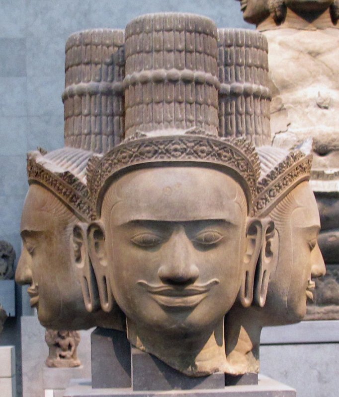
 The bust of Brahma from Phnom Bok
Source: http://commons.wikimedia.org/wiki/Category:Phnom_Bok#mediaviewer/File:Cambogia,_brahma,_da_phnom_bok,_stile_di_bakheng,_890-910_ca._01.JPG
Author: Sailko

Author: Sailko

There is a ruins of a temple on Phnom Bok. The temple was built in the 9th or 10th century, during the reign of King Yasovarman I (AD 889-910).
Phnom Bok.
One of the prasat, or tower, of Phnom Bok.
Another view of Phnom Bok.
Getting there
Phnom Bok is 221 meters (725 feet) above sea level. It is located 25 km from Siem Reap. To reach it (see map below), take Highway 6 heading east, then continue on Route 67 heading north. At the junction shown below, turn right ( on map).
Turn right here, from Route 67 to Route 810.
Continue on Route 810. When the road forks two, take the left fork (
 on map).
Take the left fork here.
Continue on Route 810 until you reach an intersection (see below). Turn left here (
 on map).
Turn left at this intersection.
Now go all the way until you reach Phnom Bok.
 Latest updates on Penang Travel Tips
 Map of Roads in Penang
Looking for information on Penang? Use this Map of Roads in Penang to zoom in on information about Penang, brought to you road by road.
Copyright © 2003-2025 Timothy Tye. All Rights Reserved.

 Go Back