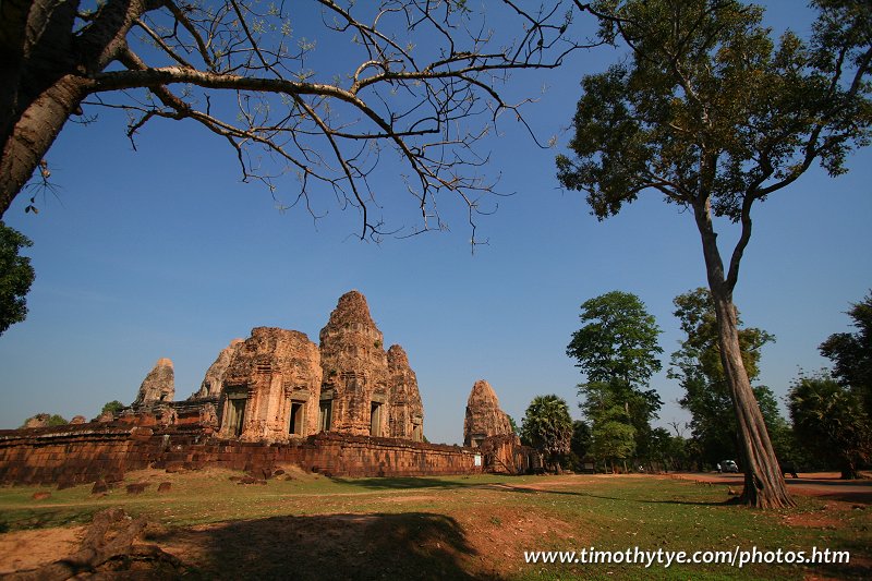
 Pre Rup (24 February, 2006)
Pre Rup (GPS: 13.4348, 103.9207), also written as Prasat Pre Roup, is the state temple of King Rajendravarman. This monument is located on a bend of the road between Srah Srang and East Mebon. It was built in the 10th century by the king who reigned from AD 944 to AD 968. The style of Pre Rup is similar to East Mebon (and that gives me some trouble trying to tell one from the other, as I often visit them together). However, Pre Rup is superior to East Mebon in terms of its craftsmanship.
360° View of Pre Rup on Google Maps Street View
Pre Rup is  in the centre of the Map of Angkor
Rajendravarman is the cousin of Jayavarman IV. During Jayavarman IV's reign, the capital was at Koh Ker, far from Angkor. After his death, there was a power struggle. One of his sons succeeded to the throne, but only for a few years. After he died, Rajendravarman took over. He shifted the capital to the south bank of the East Baray (which today is now dry), and established Pre Rup at its centre.
As with all the names of the ruins in Angkor, the name Pre Rup is a modern name, not the ancient name. The ancient name of this temple is Rajendrabhadresvara. The name Pre Rup is misleading and irrelevant, for it means "turning the body", and refers to the turning of the corpse during cremation. I am not sure how this reference made its way into the modern name of this temple. At least it gives tour guides something to talk about!
 The view of the terraces at Pre Rup (24 February, 2006)
Like other Angkor state temples including Bayon and Phnom Bakheng, Pre Rup is located right at the centre of the city. Rajendravarman's city extends till the south bank of the East Baray. As this is half a kilometer north of Pre Rup, the size of Rajendravarman's city must have been one sq kilometer.
A laterite wall surrounds the temple on each of its four sides. There is a big gopura with three doorways on each side of the wall. Entering from the main entrance at the east gopura, we saw a row of six towers, grouped three on each side of the east gopura. A steep staircase goes up from the east gopura to the first tier, which is in the inner enclosure.
The inner enclosure measures 87 meters east to west and 77 meters north to south. Like the outer enclose, it is also punctuated by gopuras at the cardinal points. The stairways lead to the second tier, where we find two libraries facing east. Steep stairways at cardinal points continue up to the third and final tier, where there are four towers, or prasats.
From this top tier, you can get a good view of the surrounding areas. You can look eastwards all the way to the Kulen hills and westwards towards Angkor Wat. Pre Rup is is best seen in the morning, so that you can get the morning sun to brighten the stones, giving them a warm, rich tone.
How to reach Pre Rup
The most usual direction to approach Pre Rup is from Srah Srang. The alternative is to come from East Mebon. Pre Rup is located 2.3km from Srah Srang and 1.3km from East Mebon. Coming from the direction of East Mebon, it is also 300 m from the left turn that leads to Banteay Samre and Banteay Srei.Pre Rup is big, and being located at a bend in the road, it's unlikely to miss. If you are on a packaged tour, then I cannot guarantee whether it will include East Mebon too. But if you are travelling independently, the best way to arrive here is by tuk tuk. I can recommend the tuk tuk driver who drove me. His name is Mr Han (see contact below), and you can call to see if he is available to take you.
 Latest updates on Penang Travel Tips
 Map of Roads in Penang
Looking for information on Penang? Use this Map of Roads in Penang to zoom in on information about Penang, brought to you road by road.
Copyright © 2003-2025 Timothy Tye. All Rights Reserved.

 Go Back