 View of the Giant's Causeway in Northern Ireland
Source: https://commons.wikimedia.org/wiki/File:Giant%27s_Causeway_%2814%29.JPG
Author: Chmee2

Northern Ireland is one of the four component countries of the United Kingdom. It covers 13,843 sq km (5,345 sq mi) and has a population of 1.8 million people (2011 estimate). Its capital and largest city is Belfast.
Northern Ireland observes the Greenwich Mean Time (GMT), which in informal use can be considered equivalent to the Coordinated Universal Time (UTC+0). The official currency here is the Pound sterling (GBP). Traffic is driven on the left here, as is in the rest of Britain. The phone IDD code is +44.
Cities in Northern Ireland on this website
Cities and Towns of Northern Ireland
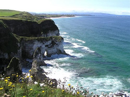
 The White Rocks in Portrush, Northern Ireland
Source: https://commons.wikimedia.org/wiki/File:The_White_Rocks,_Portrush_-_geograph.org.uk_-_222351.jpg
Author: Kenneth Allen

Northern Ireland was created out of the the former Irish province of Ulster, which now comprises Northern Ireland (with six of Ulster's nine counties) and a part of the Republic of Ireland (with three). Since then, name often Ulster is often used informally to denote Northern Ireland.
Northern Ireland had a 2002 estimated GDP of £33.2 billion, at purchasing power parity, equivalent to a per capita GDP of £19,603. Its economy is based on a number of industries including shipbuilding and textile, with an increasingly dominant role played by the services industry. Tourism is also becoming an important component in the economy of Northern Ireland.
Northern Ireland experiences a temperate maritime climate. There are four distinct seasons, while on a regional basis, the western part of Northern Ireland tends to be wetter than the eastern. July is the warmest month, with average high temperatures of 18°C (64°F). January is the coldest month, with average low temperature of 2°C (36°F).
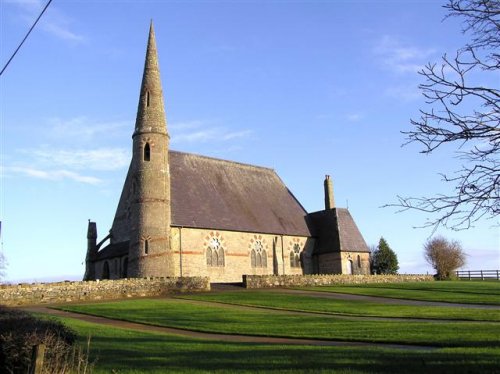
 St Patrick's Church, Ballyclog, County Tyrone
Source: https://commons.wikimedia.org/wiki/File:St_Pat%27s_Church_of_Ireland,_Ballyclog_-_geograph.org.uk_-_290340.jpg
Author: Kenneth Allen

The history of Northern Ireland can be traced to the colonization of the Kingdom of Ireland by the English king, Henry VII, in 1542. The Irish put up fierce resistance against English rule. Following their defeat in the Battle of Kinsale (1601-02), the Irish aristocracy fled Ireland, and the land was taken over by settlers from England and Scotland.
Due to continual demand for independence, Ireland eventually split into two parts in 1921. The autonomous southern part became the Irish Free State, the precursor of the Republic of Ireland. The northern part remains with Great Britain, and became Northern Ireland.
Visiting Northern Ireland
Northern Ireland has the same immigration requirements as the rest of Britain. The George Best Belfast City Airport (BHD), located just two miles from the Belfast city center, serves mainly domestic flights from most major cities in Britain.International flights to Northern Ireland land at the Belfast International Airport (BFS). The airport gets flights from many major cities in Europe.
Counties of Northern Ireland
- County Antrim
- County Armagh
- County Londonderry
- County Down
- County Fermanagh
- County Tyrone
Major Attractions of Northern Ireland
- Marble Arch Caves
- Mourne Mountains
- Rathlin Island
World Heritage Sites in Northern Ireland
- Giant's Causeway and Causeway Coast
 Latest updates on Penang Travel Tips
 Map of Roads in Penang
Looking for information on Penang? Use this Map of Roads in Penang to zoom in on information about Penang, brought to you road by road.
Copyright © 2003-2025 Timothy Tye. All Rights Reserved.

 Go Back