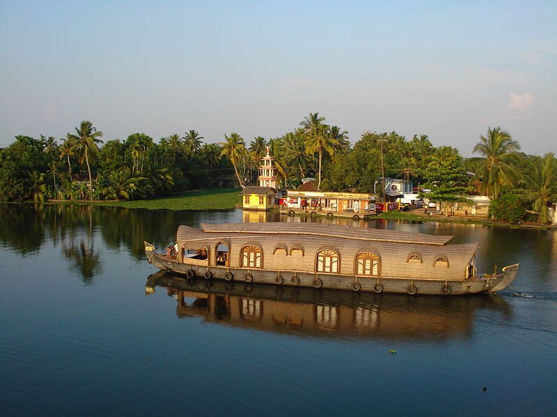
 A boat in Kuttanad, in the Kerala backwaters
Source: http://commons.wikimedia.org/wiki/File:A_view_of_Kuttanad..%E0%B4%95%E0%B5%8
1%E0%B4%9F%E0%B5%8D%E0%B4%9F%E0%B4%A8%E0%B4%BE%E0%B4%9F%E0%B5%8D,_%E0%B4%92%E0%B4%B0
%E0%B5%81_%E0%B4%A6%E0%B5%83%E0%B4%B6%E0%B5%8D%E0%B4%AF%E0%B4%82.jpg
Author: Reji Jacob

1%E0%B4%9F%E0%B5%8D%E0%B4%9F%E0%B4%A8%E0%B4%BE%E0%B4%9F%E0%B5%8D,_%E0%B4%92%E0%B4%B0
%E0%B5%81_%E0%B4%A6%E0%B5%83%E0%B4%B6%E0%B5%8D%E0%B4%AF%E0%B4%82.jpg
Author: Reji Jacob

Kerala കേരളം) is a state of India located on the southwestern coast of the Indian subcondinent. The coast where Kerala is located is known as the Malabar coast. The state covers 38,863 sq km (15,005 sq mi) and has a population of 33.4 million people. The capital of Kerala is Thiruvananthapuram.
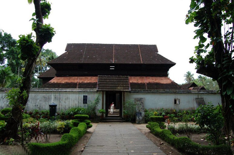
 Krishnapuram Palace, Kerala
Source: http://commons.wikimedia.org/wiki/File:Krishnapuram_palace2.jpg
Author: Appusviews

Author: Appusviews

Cities in Kerala
Kerala is today an increasingly popular travel destination in southern India. Visitors come to kerala to explore its backwaters and to experience its famed Ayurvedic treatments. The majority of the population are of Malayali descent. As such, the official language of Kerala is Malayalam, with Tamil, Tulu, Kannada and Hindi also spoken. The state has a population density which is three times that of India as a whole, but its population growth is today India's lowest.
Kerala has developed its culture, particularly in the area of performing arts. Among the artform of Kerala include the koodiyattom, the kathakali, the Kerala natanam, the Kaliyattam, the koothu, the mohiniaattam, Theyyam, and others. The koodiyattam has found recognition from UNESCO as an intangible heritage of humanity. Kathakali and Mohiniattam are recognized as among the classical dances of India.
The economy of Kerala is based on tourism, agriculture and fishing. Among the crops grown in the state include coconut, tea, coffee, rubber, cashews and spices. Traditional industries employ around a million people. They include handicrafts and handlooms. Tourism today has become one of the major industries in Kerala. In addition, a substantial number of Kerala's workforce is employed in foreign countries such as the United Arab Emirates and Saudi Arabia. Their remittences acount for a fifth of Kerala's gross state domestic product (GSDP).
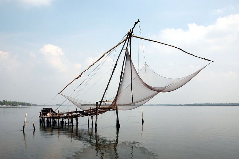
 Kochi Chinese fishing net, Kerala
Source: http://commons.wikimedia.org/wiki/File:Kochi_chinese_fishing-net-20080215-01a.jpg
Author: Hans A. Rosbach

Author: Hans A. Rosbach

Kerala is located between the Lakshadweep Sea and the Western Ghats. The state is long and narrow, about 590 km (370 mi) in length but only from 35 km (22 mi) to 120 km (75 mi) in width. The eastern part of Kerala has high mountains rising to about 1,500 m (4,920 ft). The tallest peak in Kerala is Anamudi, at 2,695 m (8,130 ft). The western coastal areas of Kerala has a lace of interconnecting canals, known as the Kerala Backwaters. Lake Vembanad, the biggest lake in the state, is located here.
Kerala experiences the wet and maritime tropical climate. The average temperature is quite uniform at around 26°C in the coastal areas. The state occasionally expereince torrential downpoursm especially during the southwest summer monsoon, as well as droughts.
How to go to Kerala
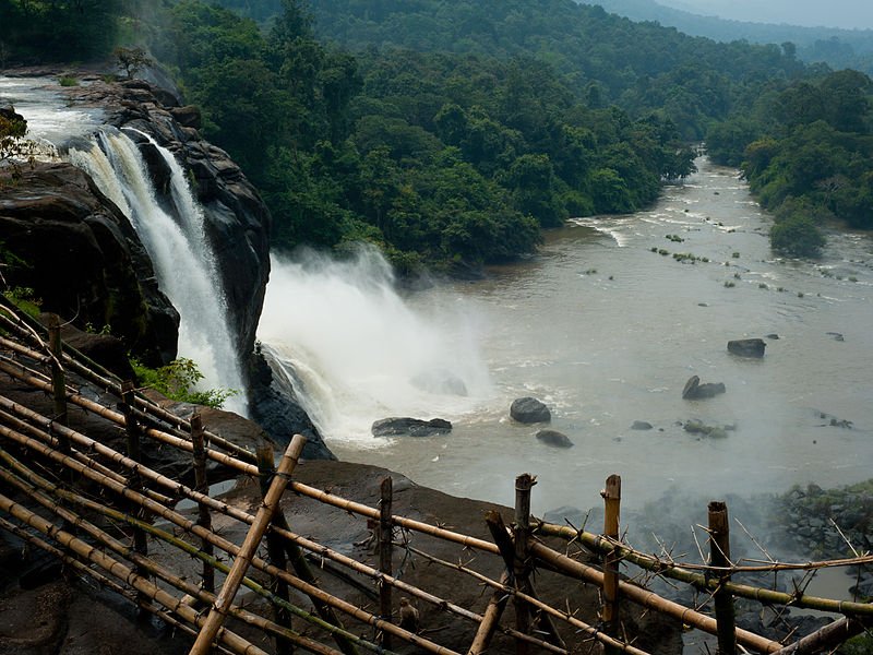
There are three international airports in Kerala, namely the Thiruvananthapuram Airport (TRV), Cochin Airport (COK) and Kozhikode Airport (CCJ). In addition to domestic destinations, most of the international flights connect Kerala with destinations in the Middle East, Southeast Asia, Sri Lanka and Maldives. Athirapally waterfalls, Kerala
Source: http://commons.wikimedia.org/wiki/File:Athirapally_waterfalls,_Kerala.jpg
Author: heb@Wikimedia Commons

Author: heb@Wikimedia Commons

Main Sights in Kerala
- Bekal Fort
- Kerala Backwaters
- Kovalam Beach
- Kumarakom
- Munnar
- Silent Valley National Park
- Thekkady
- Wayanad
- Ponmudi
Districts of Kerala
- Malabar
- Central Kerala
- Central Travancore
- Northern Travancore
- Southern Travancore
 Latest updates on Penang Travel Tips
 Map of Roads in Penang
Looking for information on Penang? Use this Map of Roads in Penang to zoom in on information about Penang, brought to you road by road.
Copyright © 2003-2025 Timothy Tye. All Rights Reserved.

 Go Back