Ibaraki Prefecture (茨城県) is a prefecture of Japan in the Kanto Region on Honshu Island. It is 6,096 sq km in size, placing it in 23rd position out of 47 prefectures. Its population of just under 3 million (2011 estimate) puts it in the 11th spot. The city of Mito is the prefectural capital.
Ibaraki Prefecture faces the Pacific Ocean, with Fukushima Prefecture to the north, Tochigi Prefecture to the west, Gunma Prefecture and Saitama Prefecture to the southwest and Chiba Prefecture to the south. While most of Ibaraki Prefecture is flat and punctuated with lakes, the northernmost part is mountainous.
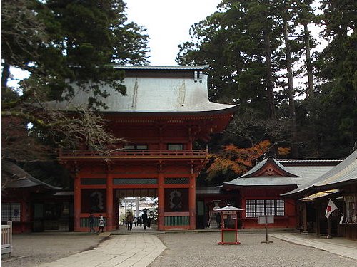
 Kashima Shrine, Kashima City, Ibaraki Prefecture
Source: http://commons.wikimedia.org/wiki/File:Kashima-jingu_romon_gate.jpg
Author: Kiku-zou

Author: Kiku-zou

Culture-wise, Ibaraki Prefecture is noted as the cradle for the Aikido martial arts, developed by master Ueshiba Morihei in the early 20th century. The prefecture is also renowned as a producer of natto, or sticky fermented soybean. It also produces watermelons and chestnuts.
Going to Ibaraki Prefecture
By TrainThere are no Shinkansen bullet trains serving Ibaraki Prefecture, so you have to take the regular trains. The Joban Line passes thorugh Mito on its way to northern Tohoku. Rail services available include the Fresh Hitachi, which links Ueno Station in Tokyo with Mito Railway Station and the Tsukuba Express, connecting Akihabara in Tokyo with Tsukuba.
By Plane
The main airport for the prefecture is Ibaraki Airport (IBR), about 40 minutes from Mita in the city of Omitama. It receives flights from Kobe, Seoul and Shanghai.
Update
11 March, 2011A massive 9.0 magnitude earthquake shook Ibaraki prefecture around 2:46 pm local time. This was followed by a tsunami which caused much devastation to the coastal areas of the prefecture.
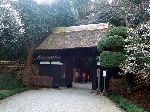
 Kairakuen Park, Mito City, Ibaraki Prefecture
Source: http://commons.wikimedia.org/wiki/File:Kairaku-en_old_front_gate.jpg
Author: Kanohara

Author: Kanohara

Cities of Ibaraki Prefecture
- Mito - capital
- Hitachi
- Kashima
- Tsukuba
Tourist Attractions of Ibaraki Prefecture
- Kairakuen Park
- Mount Tsukuba
- Kashima Shrine
 Latest updates on Penang Travel Tips
 Map of Roads in Penang
Looking for information on Penang? Use this Map of Roads in Penang to zoom in on information about Penang, brought to you road by road.
Copyright © 2003-2025 Timothy Tye. All Rights Reserved.

 Go Back