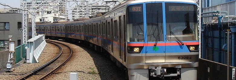
 Mita Line
Source: https://commons.wikimedia.org/wiki/File:Toei-mita-line_nisidai-hasune.jpg
Author: UE-PON2600

Author: UE-PON2600

The Mita Line (I) 三田線 is a Tokyo subway line run by the Tokyo Metropolitan Bureau of Transportation (Toei). Opened in 1968, it covers a distance of 26.5 km (16.47 mi) and has 27 stations. The line color is blue and each stop carries the letter I followed by a two-digit station number. The trains run from the Meguro Subway Station (I-01) in Shinagawa to the Nishi-Takashimadaira Subway Station (I-27) in Itabashi.
Stations on the Mita Line
| Station Number | Station Name in English | Station Name in Japanese | Interchange(s) |
| I-01 | Meguro Subway Station | 目黒 | Namboku Line (N-01), Yamanote Line |
| I-02 | Shirokanedai Subway Station | 白金台 | Namboku Line (N-02) |
| I-03 | Shirokane-Takanawa Subway Station | 白金高輪 | Namboku Line (N-03) |
| I-04 | Mita Subway Station | 三田 | Asakusa Line (A-08), Yamanote Line, Keihin-Tohoku Line |
| I-05 | Shibakoen Subway Station | 芝公園 | NONE |
| I-06 | Onarimon Subway Station | 御成門 | NONE |
| I-07 | Uchisaiwaicho Subway Station | 内幸町 | NONE |
| I-08 | Hibiya Subway Station | 日比谷 | Hibiya Line (H-07), Chiyoda Line (C-09), Yurakucho Line (Y-18), Yamanote Line, Keihin-Tohoku Line |
| I-09 | Otemachi Subway Station | 大手町 | Marunouchi Line (M-18), Tozai Line (T-09), Chiyoda Line (C-11), Hanzomon Line (Z-08) |
| I-10 | Jimbocho Subway Station | 神保町 | Shinjuku Line (S-06), Hanzomon Line (Z-07) |
| I-11 | Suidobachi Subway Station | 水道橋 | Chuo-Sobu Line |
| I-12 | Kasuga Subway Station | 春日 | Oedo Line (E-07), Marunouchi Line (M-22), Namboku Line (N-11) |
| I-13 | Hakusan Subway Station | 白山 | NONE |
| I-14 | Sengoku Subway Station | 千石 | NONE |
| I-15 | Sugamo Subway Station | 巣鴨 | Yamanote Line |
| I-16 | Nishi-Sugamo Subway Station | 西巣鴨 | Toden Arakawa Line |
| I-17 | Shin-Itabashi Subway Station | 新板橋 | Saikyo Line |
| I-18 | Itabashi-Kuyakushomae Subway Station | 板橋区役所前 | NONE |
| I-19 | Itabashi-Honcho Subway Station | 板橋本町 | NONE |
| I-20 | Motohasunuma Subway Station | 本蓮沼 | NONE |
| I-21 | Shimura-Sakaue Subway Station | 志村坂上 | NONE |
| I-22 | Shimura-Sanchome Subway Station | 志村三丁目 | NONE |
| I-23 | Hasune Subway Station | 蓮根 | NONE |
| I-24 | Nishidai Subway Station | 西台 | NONE |
| I-25 | Takashimadaira Subway Station | 高島平 | NONE |
| I-26 | Shin-Takashimadaira Subway Station | 新高島平 | NONE |
| I-27 | Nishi-Takashimadaira Subway Station | 西高島平 | NONE |
 Latest updates on Penang Travel Tips
 Map of Roads in Penang
Looking for information on Penang? Use this Map of Roads in Penang to zoom in on information about Penang, brought to you road by road.
Copyright © 2003-2025 Timothy Tye. All Rights Reserved.

 Go Back