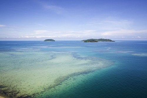
 Pulau Sulug, left, Pulau Mamutik, front, Pulau Manukan, back
 https://commons.wikimedia.org/wiki/File:KKseaisland.jpg
 Flanegan
Tunku Abdul Rahman National Park is a national park just offshore from Kota Kinabalu, Sabah. Established in 1974 and named after the first prime minister of Malaysia, Tunku Abdul Rahman National Park covers an area of 49 sq km. Two thirds of the area is the sea while the remainder are exposed coral reefs and five small islands. The islands are part of the Crocker Range rock formation lying on the western coast of the state, formed when changes in sea level submerged park of the mountain range to form these islands. Caves, cliffs and crevasses are common regular feature of these islands.
The main islands within the Tunku Abdul Rahman National Park are as follows:
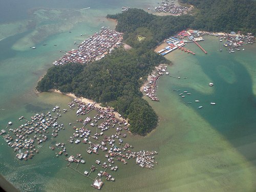
 Stilt village of Filipino immigrants at Pulau Gaya
 https://commons.wikimedia.org/wiki/File:Pulau_Gaya_immigrant_dwellings.jpg
 Thien Zie Yung
The island of Pulau Gaya was the original Jesselton. It was developed by the British North Borneo Company as a trading settlement in 1882. Later on, a site on the Borneo mainland was developed, and the name Jesselton moved there. In 1968, the mainland Jesselton was renamed Kota Kinabalu.
When Tunku Abdul Rahman National Park was established in 1974, it covered parts of Pulau Gaya aznd Pulau Sapi, covering an area of 36.4 sq km (8990 acres). This was increased in 1979 to 49.2 sq km (12185 acres) with the inclusion of Pulau Manukan, Pulau Mamutik and Pulau Sulug.
Getting there
Tunku Abdul Rahman National Park Location Map
List of National Parks in Sabah and National Parks in Malaysia
 Latest updates on Penang Travel Tips
 Discover with Timothy videos on Sabah
What to see when in Sabah? Here are some suggestions from my videos.Disclaimer
Please use the information on this page as guidance only. The author endeavours to update the information on this page from time to time, but regrets any inaccuracies if there be any.
Copyright © 2003-2025 Timothy Tye. All Rights Reserved.

 Go Back