 Beach near Puerto Galera in Mindoro
 http://commons.wikimedia.org/wiki/File:Beach_North_Mindoro_Philippines.jpg
 Magalhães
Mindoro is one of the main islands of the Visayas in the Philippines. It is located to the immediate south of Luzon, with its southern coast facing the northeastern reaches of the Sulu Sea. From Mindoro, the island of Panay is to the southeast while the island of Palawan is to the southwest.
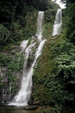
 Tamaraw Falls, Mindoro
 http://commons.wikimedia.org/wiki/File:Tamaraw_Falls,_Mindoro,_Philippines.jpg
 Kok Leng Yeo
Mindoro covers 10,572 sq km (4,081 sq mi) and has a population of slightly over a million people. Until 1950, Mindoro was administered as a single province. Since then it is divided into the province of Occidental Mindoro and Oriental Mindoro.
The island of Mindoro is still rural, with its population dependent on agriculture. Among the crops grown on the island includes bananas, citrus, rambutan and coconuts.
Mindoro is also becoming a popular tourist destination, partly due to its relative proximity to Manila. The people speak Tagalog, though many are now fluent in English. Contact with Chinese traders for hundred of years means that there is a small community of ethnic Chinese speaking the Fukien dialect similar to Taiwan, Singapore, Penang and Fujian Province of China.
Places of Interest in Mindoro
- Lubang Island
Island to the northwest of Mindoro with beautiful beaches. - Puerto Galera
Town on the northern coast of Mindoro famous for its beaches with excellent snorkeling and scuba diving spots. Its bay has been voted as some of the most beautiful in the world.
 Latest updates on Penang Travel Tips
 Map of Roads in Penang
Looking for information on Penang? Use this Map of Roads in Penang to zoom in on information about Penang, brought to you road by road.
Copyright © 2003-2025 Timothy Tye. All Rights Reserved.

 Go Back