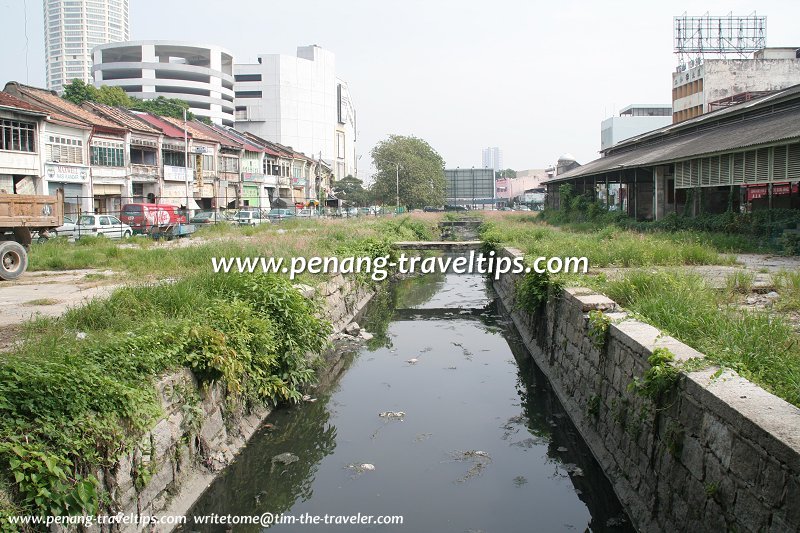
Prangin Canal (7 July 2008)

Prangin Canal is a canal that used to mark the limits of George Town. The canal was originally a river that flowed into the swampy coastline as it emptied into the sea. After George Town was established, the Prangin River became a vital waterway where sampans and perahus bring goods from the harbour into the hinterland. Indeed, as recently as the 1950's, tongkangs and perahus were still going up the Prangin Canal to bring produce to the Sia Boey Market
 .
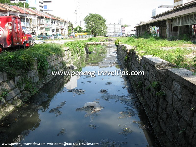
.The canalization of Prangin River began as early as 1804. This changed a meandering river of largely obscure route into a clearly defined canal. The Prangin Canal is approximately 20 feet wide and 5 feet deep. The sides comprise granite stones and blocks, while the base is concrete overlying the silt stratum.
I had a meeting with the state government last year (2009), as they were interested in rehabilitating that part of George Town, and I happened to have done the research into its history. According to engineers at the MPPP (Penang Island Municipal Council), that part of George Town was swampy land, and the canal was originally a river through the mangrove swamps. This sounds logical, considering Carnarvon Street was known as Lam1 Chan3na4, meaning "soggy rice fields".
In the 19th Century, George Town reached only to the Prangin Canal. The edge of town along the Prangin Canal was called Sia Boey in Hokkien, meaning "Town's End". Across there river, where Maxwell Road is located, there was a Chinese village called Kuay Kang-nga, meaning "across the river".
A few plank bridges crossed the Prangin Canal, connecting the "town side" to the "country side". It should be remembered that none of the shophouses we see today in the area beyond the Prangin Canal existed until the late 19th Century, when they were built to replace the attap huts which were there.
When George Town extended across the Prangin Canal, a new set of seven parallel roads were built in the Koay1 Kang3nga4 settlement. These seven main roads gave the place its name of Seven Streets Precinct, or Chit1 Tiau3 Lor33. (In fact there are more than seven streets.)
While the English roadnames honored members of the European merchant community, the Hokkien names for the nine roads follow a numbering system according to their proximity to Prangin Canal. Ergo, Magazine Road was Thau Tiau Lor, or "1st St." - that's an abbreviation of Kuay Kang-nga Thau Tiau Lor, meaning "1st St. Across the River". The last one was Sandilands Street, which is Kau Tiau Lor in Hokkien.
At the seaward end of Prangin Canal was Anson Bridge, named after Archibald Anson, the Lieutenant Governor of Penang from 1867-1882 (read Governors of the Straits Settlements). The bridge is gone (correction: the bridge is still there, but not very visible, I checked March 2010 and have photos to show, read Anson Bridge), but the name lives on elsewhere as a major road in Penang. Anson Bridge linked Beach Street to Bridge Street, which continued into the hinterland. Until the land reclamation of 1880, these two streets were located by the sea shore, and the Malays called this area Hujung Pasir.
At the other end of Prangin Canal was a drawbridge across Penang Road, and the Hokkien called that area of town Tiau Keo Th'au (meaning "head of the drawbridge"). The Malays called it Titi Papan, and the name is commemorated by Masjid Titi Papan nearby.
The Prangin Canal connected to another ditch at Transfer Road. The ditch emptied into the sea at North Beach, creating an island out of the inner city of George Town. At that time, small sampans could come down from the north all the way to Keramat Dato Koyah.
Before 2013, the Prangin Canal served as a large monsoon drain into which the drains in the surrounding area empty into. The catch is about 278 acres. The area marked by the Prangin Canal and that long-gone ditch is the approximate location of the present-day core zone of the George Town Unesco World Heritage Site.
The name Sia Boey became synonymous with the wholesale market that existed along the Prangin Canal through the 20th Century. The Sia Boey market was relocated a few years ago to Kompleks Pulau Mutiara at Macallum Street Ghaut, while the area along the Prangin Canal, where the market used to occupy, is awaiting redevelopment.
Today much of Prangin Canal has been filled up. The small section that is still visible is located where the Sia Boey market used to be.The redevelopment of the area around the Prangin Canal area may spell the end of the historic canal, so it is hoped that this article will ensure the history is not lost.
Rejuvenation of the Prangin Canal
From 2013, a project was underway to rejuvenate the Prangin Canal area, also known as Sia Boey Rejuvenation Project. As part of the enabling works, the water of the Prangin Canal was diverted to a new culvert that is parallel to the existing canal. Plans for the diversion were presented to, and approved by the Penang Island City Council (MBPP) and the Technical Review Panel, which includes Penang Heritage Trust, a member of the Penang Forum coalition.The discovery of a granite structure, later identified as the Old Prangin Canal Basin by Universiti Sains Malaysia's Centre for Global Archaeological Research, inspired Penang Development Corporation (the project owner) and George Town World Heritage Incorporated (the project partner) to transform the Sia Boey area into the first urban archaeological park in Malaysia.
Rehabilitation works were carried out from May until August 2018, after the Prangin Diversion was completed in October 2016. This allows the old section of the Prangin Canal to be thoroughly cleaned and rejuvenated into a water feature that flows within the new proposed park.
Getting there
From the Komtar Bus Terminal, walk along Lebuh Tek Soon and then turn left into Lebuh Lintang, which is under Prangin Mall. At the junction of Jalan Dr Lim Chwee Leong, turn right, walk along the road until you reach the disused Sia Boey Market building. The Prangin Canal is located behind the market building.Street Art
Nearby Sights
Nearby Shopping
 The stagnant Prangin Canal, George Town (4 December 2008)
Location of Praingin Canal on the map
List of Historic Buildings in Penang and Historic Buildings in Malaysia

Copyright © 2003-2025 Timothy Tye. All Rights Reserved.

 Go Back