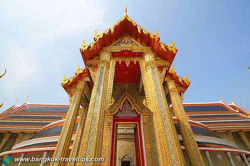
 Wat Ratchanaddaram (29 August 2006)
Wat Ratchabophit is a royal temples of the highest rank. Its full name is Wat Rajabopitsathitmahasimaram. Located along Fuang Nakhon Road a short distance to the east of Wat Pho, Wat Ratchabophit was built by King Chulalongkorn (Rama V), to continue the royal tradition of erecting and naming a royal temple to his reign. Construction of Wat Ratchabophit began in 1869, one year into the reign of Rama V. The architects of the temples are all relatives to the kings.
The name of the temple, Rajabopitsathitmahasimaram, means Temple under the Royal Construction with the Great Sacred Boundaries.The temple was intended to be the residence of the monks of Thamayutinikaya Sect.
 Wat Ratchanaddaram (29 August 2006)
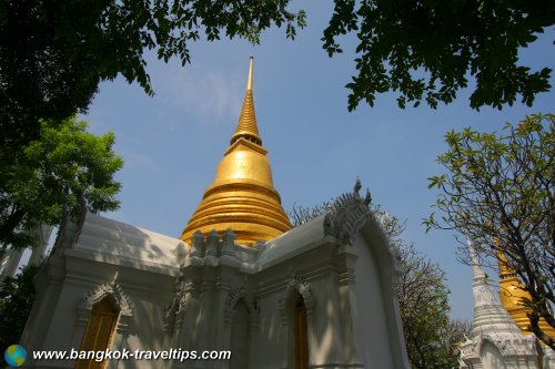
The most iconic structure at Wat Ratchabophit is its stupa, the Phra Chedi. It is in the form of a round bell with a slim spire. Inside relics of the Buddha is kept. Around the stupa are sixteen niches with images of Buddha in different poses.
One of the most interesting discoveries for me at Wat Ratchabophit is the amusing 'farang' door guards on the door of the temple. These "European" guards wear blue uniforms and are a surprising find in the temple.
Wat Ratchabophit is also an important Royal Mausoleum. The royal cemetery is located on the west side of the temple and houses the ashes of the various members of the royal family.
 Wat Ratchanaddaram (29 August 2006)
Getting there
Wat Ratchabophit is located along Fuang Nakhon Road to the east, and bordered by Thanon Ratchabophit to the north and Thanon Atsadang to the west. From Wat Pho, walk east along Charoen Krung Road, cross the Khlong Lod canal until you reach Thanon Fuang Nakhon. Turn left and you arrive at Wat Ratchabophit to your right.The easiest way to reach this part of Bangkok is by taxi. Otherwise, you can also take the BTS Skytrain to the Saphan Taksin Station (S6)) and then catch a ferryboat to Thien Pier (N8).
Note an inaccurary in Google Map where Wat Ratchabophit is inaccurately labelled too far to the east when you zoom in. To view the correct location, change to satellite view.
Location: Fuang Nakhon Road
Nearest Boat Pier: Thien Pier (N8)
Opening hours: 5:00am-8:00pm Entrance fees: none
Tel: 0-2222-3930
 Wat Ratchanaddaram, east entrance (29 August 2006)
 Wat Ratchanaddaram, 'farang' door guard, east entrance (29 August 2006)
 Wat Ratchanaddaram, sala rai (29 August 2006)
 Phra Vihara Thit, Wat Ratchanaddaram (29 August 2006)
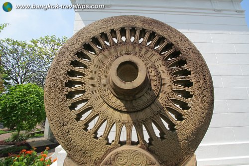
 Buddhist Wheel of Law (Dhammachak), Wat Ratchanaddaram (29 August 2006)
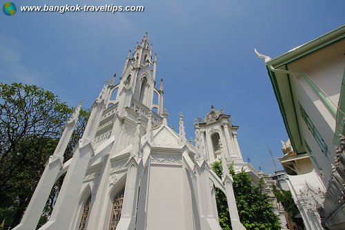
 Royal mausoleum, Wat Ratchanaddaram (29 August 2006)
 Royal mausoleum, Wat Ratchanaddaram (29 August 2006)
 [an error occurred while processing this directive]
List of Wats in Bangkok and Wats in Thailand; list of Districts of Bangkok
 Latest updates on Penang Travel Tips
 Map of Roads in Penang
Looking for information on Penang? Use this Map of Roads in Penang to zoom in on information about Penang, brought to you road by road.
Copyright © 2003-2025 Timothy Tye. All Rights Reserved.

 Go Back